How to combine participatory mapping and other sensing systems in support of urban sustainability transformation

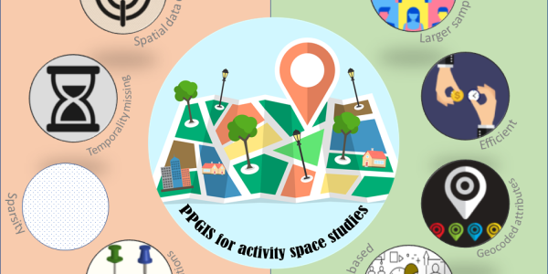
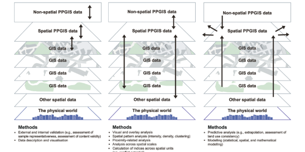
Members of the Participatory Mapping Institute have just published a journal article on “Harnessing sensing systems towards urban sustainability transformation”.  This paper presents a novel set of conceptual frameworks to show how participatory mapping, classed as an active sensing system, could be combined with passive sensing systems like big data collated from social media  to secure an inclusive, sustainable and resilient urban transformation. The paper derives principles for sustainability planning, including an iterative dialogue along a sensing loop, new modes of governance enabling direct feeding of sensed information, an account for data biases in the sensing processes and a commitment to high ethical standards, including open access data sharing.

For the full text see: Grêt-Regamey, A., Switalski, M., Fagerholm, N. et al. Harnessing sensing systems towards urban sustainability transformation. npj Urban Sustain 1, 40 (2021). doi.org/10.1038/s42949-021-00042-w

active sensing, big data, participatory mapping, passive sensing, social media

New publication exploring the pros & cons of using PPGIS data for activity space modeling

This paper focuses on the use of public participation GIS (PPGIS) data in activity space modeling and analysis and aims to draw more scholarly attention to the existing research potentials in this area. While reviewing the pros of using PPGIS for activity space studies, this paper also discusses the existing limitations and outlines how they can be addressed in future research.

Access article for free: doi.org/10.1007/s10708-021-10489-0

activity space, GIS, PPGIS

Open Geo Hub: Spatial Data Anonymization Made Easy

If you’re interested in open data and want to try anonymizing some of your spatial datasets here’s some good news for you:

We have launched a GIS web app where you can anonymize your point data for free. The app can be accessed here: www.geohub.site

Using this tool you can anonymize your data using two methods:

  • a simple but efficient donut anonymization
  • An advanced context sensitive anonymization algorithm.

The tool is based on the method developed in the following study:

Hasanzadeh, K., Kajosaari, A., Häggman, D., & Kyttä, M. (2020). A context sensitive approach to anonymizing public participation GIS data: From development to the assessment of anonymization effects on data quality. Computers, Environment and Urban Systems, 83, 101513.

This is a beta version of the tool and all feedback are welcome at this stage. If you have any inquiries, please find the contact information on  www.geohub.site.

The tool currently only supports point data. More functionalities will be added to the hub in future.

anonymization, open data, open science, PPGIS

ISPM: Join the International Society of Participatory Mapping’s Executive Committee

International Society for Participatory Mapping (ISPM):

We are an eager group of collaborators including graduate students, faculty members, volunteers, and practitioners. The formation of a participatory mapping international organization is well-timed with the proliferation of mapping technologies, crowdsourcing platforms and social justice issues emerging in every corner of the world.

Participatory Mapping is the field of research and practice engaged in leveraging geographic technology to support public participation. Applications for participatory mapping methods range from indigenous rights, to smart cities, to biodiversity conservation. Our organization is unique in that we embrace the interdisciplinarity of the challenges faced at all levels of community and governance.

The ISPM was conceptualized at the first International Participatory Mapping Conference at Cal Poly in July 2017. Since then, we’ve formed a small group of academics, practitioners, and activists who believe in the ideals of participatory mapping and its potential for promoting equality and social justice.

The Society strives to provide opportunities for underprivileged and marginalized communities in order to promote a more equal distribution of knowledge and resources. The Official Bylaws outline the organizational structure of the Society. The tenure is a minimum of 2 years and includes a mandatory monthly meeting, hosting a webinar or a course, and supporting general operations.

These purposes are to be carried out by:

  • Hosting our Society on Mighty Networks to stimulate communication between practitioners and academics;
  • Electronically housing participatory mapping data, including maps, publications, workshops, and trainings;
  • Promoting the International Journal of Participatory Mapping (IJPM);
  • And the execution of quarterly webinars that engage researchers and practitioners publishing in IJPM.

For more information please visit our website and join our public network. To get involved, please take this survey and the committee will reach out shortly.

ISPM, PPGIS

New paper out on a methodological framework for analysis of participatory mapping data in research, planning, and management

This new paper by Fagerholm et al. (2021) presents a framework of methods for categorizing PPGIS data.  We consider three phases:  Explore, Explain, and Predict/Model. Explore involves descriptive and univariate analysis of PPGIS data and generation of visual outputs. Spatial patterns are identified for one attribute at a time (univariate analysis) and compared across available attributes. Explain seeks to look more closely at observations than the Explore phase, in order to explain observations by further analysis. Predict/Model aims to generalize and predict mapped attributes to other places and contexts (prediction) or produce a representation of a system to make inferences (model).

https://doi.org/10.1080/13658816.2020.1869747

Participatory Mapping Institute
Copyright 2020