Increased interest in comparing PPGIS and social media data
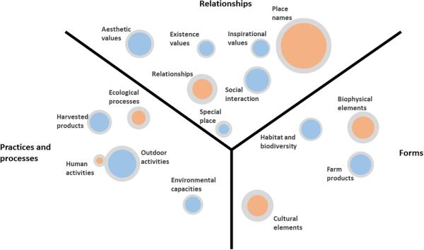
A recent publication by Stahl Olafsson et al. (2022) has explored 19 case sites across Europe to compare perceived landscape values applying and comparing both PPGIS and geolocated social media (Flickr) data. Authors find more cross-site differences than similarities both in spatial patterns and value types. Most agreement in spatial patterns across the two data sets are found in densely populated landscapes; however, comparison of types of perceived landscape values is challenged by the differing assumptions of each value elicitation technique. The results show that PPGIS elicits a wider spectrum of values, while Flickr mainly elicits relationships to and with landscapes. The authors argue for the complementary potential of both approaches and highlight the strengths and weaknesses of using the two together in landscape research, planning and management.
Please check the article below to read more about this study:
Olafsson, A.S., Purves, R.S., Wartmann, F.M., Garcia-Martin, M., Fagerholm, N., Torralba, M., Albert, C., Verbrugge, L.N., Heikinheimo, V., Plieninger, T. and Bieling, C., 2022. Comparing landscape value patterns between participatory mapping and geolocated social media content across Europe. Landscape and Urban Planning, 226, p. 104511. doi.org/10.1016/j.landurbplan.2022.104511
Interested to read more about this topic? Over the recent years, studies have increasingly addressed such comparative setting between PPGIS and geolocated social media data. Check for example the following articles:
Depietri, Y., Ghermandi, A., Campisi-Pinto, S. and Orenstein, D.E., 2021. Public participation GIS versus geolocated social media data to assess urban cultural ecosystem services: Instances of complementarity. Ecosystem Services, 50, p. 101277. doi.org/10.1016/j.ecoser.2021.101277
Heikinheimo, V., Tenkanen, H., Bergroth, C., Järv, O., Hiippala, T. and Toivonen, T., 2020. Understanding the use of urban green spaces from user-generated geographic information. Landscape and Urban Planning, 201, p. 103845. doi.org/10.1016/j.landurbplan.2020.103845
Levin, N., Lechner, A.M. and Brown, G., 2017. An evaluation of crowdsourced information for assessing the visitation and perceived importance of protected areas. Applied geography, 79, pp. 115-126. doi.org/10.1016/j.apgeog.2016.12.009
Muñoz, L., Hausner, V.H., Runge, C., Brown, G. and Daigle, R., 2020. Using crowdsourced spatial data from Flickr vs. PPGIS for understanding nature’s contribution to people in Southern Norway. People and Nature, 2(2), pp. 437-449. doi.org/10.1002/pan3.10083