New paper out on a methodological framework for analysis of participatory mapping data in research, planning, and management
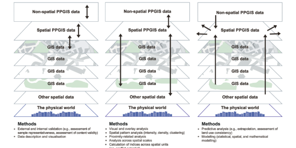
This new paper by Fagerholm et al. (2021) presents a framework of methods for categorizing PPGIS data. We consider three phases: Explore, Explain, and Predict/Model. Explore involves descriptive and univariate analysis of PPGIS data and generation of visual outputs. Spatial patterns are identified for one attribute at a time (univariate analysis) and compared across available attributes. Explain seeks to look more closely at observations than the Explore phase, in order to explain observations by further analysis. Predict/Model aims to generalize and predict mapped attributes to other places and contexts (prediction) or produce a representation of a system to make inferences (model).