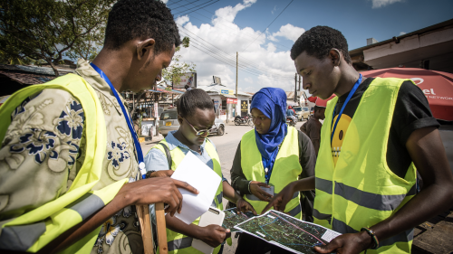
Mapping for flood resilience with communities in Dar es Salaam city Tanzania
Project description
“Ramani Huria”, a Swahili word for “Open Maps”, is a project, which was established in 2016 to combat flood hazards in Dar es Salaam, Tanzania through community mapping. Every year during the rainy season, severe floods affect the lives of the residents, especially in the informal settlements. People lose their property and their lives are threatened. Dar es Salaam city is one of the fastest growing cities in Africa. Since there are no official ways to obtain up-to-date information on the informal settlements, Ramani Huria Project has tried to reach this gap. Students and community members create drainage maps, soil maps, flood extent and safety maps using open source tools, such as OpenStreetMap, Open Map Kit (ODK) and Open Data Kit (ODK). These provide simple and cheap ways to collect baseline data through volunteered community participation. In the annual mapping campaigns, university students learn to interview and train community members regarding the mapping and the relevance of mapping to their capacity to cope with floods.
Having local Government offices, top university students and community members participate in a shared project gives an opportunity to work together to understand flooding, risk areas and flood response. Ramani Huria project is currently sharing methodologies and tools through Resilience Academy aiming at developing training materials, sharing the geo-database and training University students from four Tanzanian universities (Sokoine University of Agriculture, State University of Zanzibar, Ardhi University and University of Dar es Salaam) jointly with their northern partner University of Turku, Finland.
More information at: ramanihuria.org/, tanzania.utu.fi/ and resilienceacademy.ac.tz/
Research themes
Open participatory science and data
Private: PPGIS and VGI methods development
Project details
-
Start date:January 1, 2014
-
End date:December 31, 2022
-
Location:Dar es Salaam, Tanzania
-
Funded by:The World Bank, University of Turku
-
Objectives:Collect data through volunteered community participation and mapping activities to create understanding and capacity to cope with urban floods
Project contact
Niina Käyhkö
Team members
- Msilikale Msilanga, World Bank
